Geography & Geology – The Landscape of James Bond Island
Phang Nga Bay is one of the most stunning natural landscapes in Southeast Asia. Its signature feature – hundreds of sheer limestone karst towers rising vertically from emerald green water – is the result of millions of years of geological processes. This page explains the geography of the bay (location, size, climate) and the geology (how the rocks formed, why they look so dramatic, and where to see the best examples). Use the links below to dive deeper into specific features.
⛰️ Explore the geology in person ⛰️
Our boat tours take you right up to the limestone towers. See sea stacks, caves, and the famous nail rock up close.
🚤 Book a Geology Tour →Geography of Phang Nga Bay
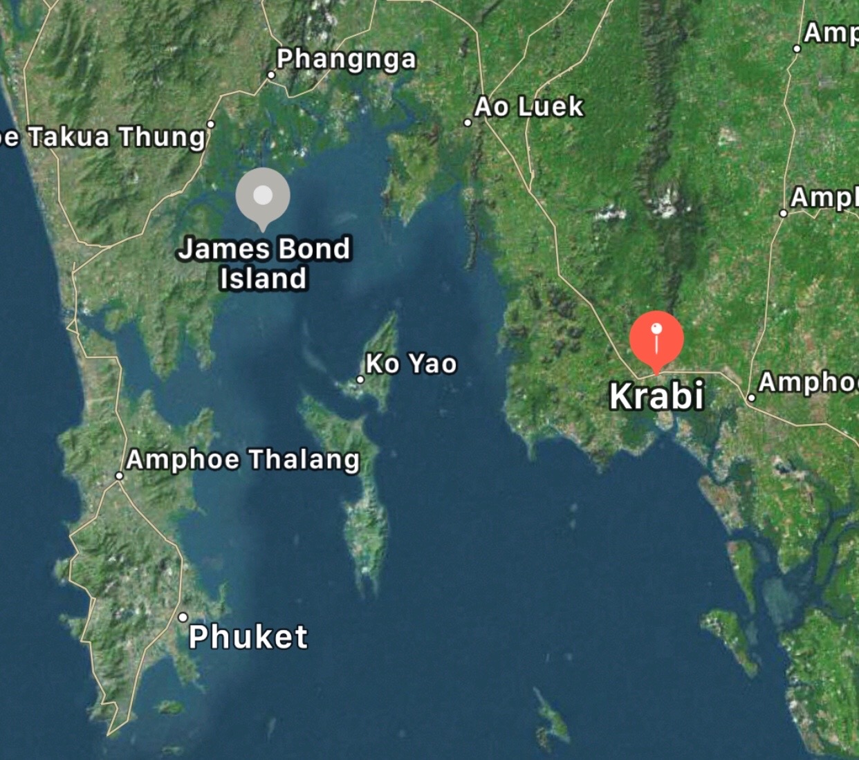
Phang Nga Bay is a 400 square kilometre sheltered bay in the Andaman Sea, between the island of Phuket and the mainland of Krabi and Phang Nga provinces. It is part of the Ao Phang Nga National Park, established in 1981. The bay contains more than 40 major limestone islands, plus dozens of smaller rock formations. The water depth ranges from 1 to 20 metres, with deeper channels for boat traffic. The bay is protected from the open sea by Phuket and other islands, so waves are generally calm – except during the monsoon season (June to October). The coordinates are roughly 8°16′N 98°30′E. James Bond Island (Khao Phing Kan) is located near the centre of the bay, about 25 kilometres north‑east of Phuket town.
Climate and Its Effect on the Landscape
The area has a tropical monsoon climate. The wet season (May to October) brings heavy rain, strong winds, and rough seas. The dry season (November to April) is hot and humid, with calm seas. Rainwater is the main agent of erosion on the limestone – the slightly acidic rain dissolves the rock over time. This process is fastest during the wet season. The constant humidity also encourages vegetation on the tops of the islands, but the sheer cliffs remain bare because plants cannot grip the vertical rock.
Geology – The Story of the Limestone Karsts
The limestone of Phang Nga Bay began forming about 295 to 250 million years ago, during the Permian Period. At that time, the area was a shallow, warm sea full of marine life – corals, crinoids, brachiopods, and foraminifera. When these creatures died, their calcium carbonate shells and skeletons accumulated on the seabed. Over millions of years, the layers of sediment were compacted and cemented into limestone rock. The limestone layer is very thick – in some places, over 1,000 metres.
Then, about 50 million years ago, the Indian tectonic plate collided with the Eurasian plate. This collision pushed up the Himalayan mountains and also uplifted large areas of Southeast Asia, including the limestone seabed. The rock was now above sea level. Rainwater, which is slightly acidic (from carbon dioxide in the air), began to dissolve the limestone along natural cracks and joints. Over tens of millions of years, the water carved deep gullies, leaving behind isolated blocks. This process is called “karstification”. When the last Ice Age ended about 10,000 years ago, sea levels rose, flooding the lowlands between the blocks. The blocks that remained above water became the islands (karst towers) we see today.
A classic example of a sea stack – a standalone rock that has completely separated from the main cliff – is Ko Tapu, the nail rock. For a full explanation of how these towers form, read our detailed Limestone Karst Formation page.
The Specific Features of James Bond Island
The twin‑hill island of Khao Phing Kan consists of two limestone blocks leaning against each other – hence the name “hills leaning together”. The gap between them forms a small sandy beach that is only exposed at low tide. About 40 metres away, the sea stack Ko Tapu (the nail rock) rises 20 metres above the water. Together, they create the iconic James Bond Island view. The rock is grey‑white with sharp edges and many small crevices where birds and bats nest. The base of Ko Tapu is undercut by wave action – this notch will eventually become deeper, and the stack will collapse in a few thousand years. For now, it remains safe to view from a distance.
Caves and Holes – How They Form
Many of the islands have caves, such as those on Panak Island and Hong Island. Caves form where water dissolves the limestone along joints, or where waves cut notches at the base. Some caves, like the “Ice Cream Cave” on Panak Island, have stalactites and stalagmites – these form from dripping water that leaves behind calcium carbonate. You can kayak into some of these caves at low tide. For a list of the best caves, see our Nearby Attractions page.
Other Geological Features in Phang Nga Bay
Besides the karst towers, the bay contains:
- Mangrove forests – at the edges of the bay, especially near the mainland. The trees grow in salty water and provide nursery grounds for fish.
- Sea caves (hôrng) – collapsed cave roofs that form enclosed lagoons, such as on Hong Island.
- Fossil reefs – some of the limestone contains visible fossils of ancient marine creatures, though you need a guide to point them out.
- Alluvial plains – flat areas behind the mangroves, now used for rubber plantations and rice paddies.
The variety of landscapes makes the bay a geological paradise. For a full tour of nearby islands, check our Nearby Islands guide.
Why the Geography Matters for Visitors
Understanding the geography helps you plan your trip. The bay is sheltered, so even on windy days, the waves are lower than in the open sea. However, during the monsoon (June‑October), wind speeds can still cancel tours. The best months for calm seas are November to April. The tide affects whether you can walk on the beach at James Bond Island – low tide is essential. The depth of the water also determines which boats can access certain caves (only longtail boats can enter shallow areas, speedboats usually cannot). For practical advice on planning, read our Practical Information page.
Frequently Asked Questions About Geography & Geology
Q: How old are the rocks of James Bond Island?
A: The limestone itself is 250‑295 million years old. The towers began taking their current shape about 2 million years ago.
Q: Why are some rocks black?
A: The black colour comes from algae and cyanobacteria that grow on the wet limestone. It is not pollution.
Q: Can I find fossils on the islands?
A: Yes, but you are not allowed to remove them. The national park protects all fossils. You may see shell imprints on some rocks.
Q: Are the karsts still eroding?
A: Yes, very slowly. Each rain shower dissolves a tiny amount of limestone. In human terms, the change is unnoticeable.
Q: Why is the water green?
A: The green colour comes from sunlight reflecting off the limestone sediment and the dense growth of phytoplankton (microscopic algae) in the nutrient‑rich water.
Q: Is the bay connected to the open sea?
A: Yes, through several channels between Phuket and the mainland. The tides flow in and out twice a day.
Further Reading on Geology & Geography
To go deeper into specific topics, see these dedicated pages:
- Limestone Karst Formation – detailed process of how the towers form.
- Khao Phing Kan (James Bond Island) – the twin‑hill island itself.
- Ko Tapu (The Nail Rock) – the famous sea stack.
- Nearby Islands – other karst islands you can visit.
- Nearby Attractions – caves, viewpoints, and mainland geology.
Final Word From Local Experts
The limestone karsts of Phang Nga Bay are not just beautiful – they are a living textbook of Earth’s history. Standing on the beach of James Bond Island, you are standing on the remains of an ancient seabed, lifted up by the collision of continents, carved by rain, and flooded by melting ice. The rock has witnessed dinosaurs, the rise of humans, and the filming of a James Bond movie. That perspective makes the visit much more meaningful. Take a moment to look closely at the rock – you might see fossils, or simply admire the patience of nature.
Remember the Thai saying: “The mountain is hard, but the heart is soft.” Respect the geology, do not damage it, and you will be welcomed back for years to come.
— Written by the team at VisitJamesBondIsland.com